Trail On foot Rožnov pod Radhoštěm - Naučná stezka Hradisko - Photo

Tous les sentiers balisés d’Europe GUIDE+

© OpenStreetMap contributors
Length
Length
3.1 km
Max alt
Max alt
519 m
Uphill gradient
Uphill gradient
152 m
Km-Effort
Km-Effort  
5.2 km
Min alt
Min alt
364 m
Downhill gradient
Downhill gradient
151 m
Boucle
Boucle
Yes
Signpost
Signpost
Creation date :
2025-02-07 08:02:31.826
Updated on :
2025-02-07 08:02:31.826

(0 Reviews)

On foot
On foot
1h10
Difficulty : Easy

Scan this QR Code to open this trail in the SityTrail application

FREE GPS app for hiking

Logo SityTrail SityTrail

IGN / Geographical institutes

Download SityTrail from the App Store Download SityTrail from Google Play

Logo SityTrail SityTrail World

The world is yours!

Download SityTrail from the App Store Download SityTrail from Google Play Download SityTrail on Huawei AppGallery

About

Trail On foot of 3.1 km to be discovered at Central Moravia, Zlínský kraj, Rožnov pod Radhoštěm. This trail is proposed by SityTrail - itinéraires balisés pédestres.

Description

Trail created by CHKO Beskydy.

Elevation profile

Photos

Positioning

Country:
Czech Republic
Region :
Central Moravia
Department/Province :
Zlínský kraj
Municipality :
Rožnov pod Radhoštěm
Location:
Unknown
Start:(UTM)
291823 ; 5482348 (34U) N.

Trails nearby

Trail On foot Hutisko-Solanec - CZ-yellow - Photo
On foot
GUIDE+

On foot

Easy
Hutisko-Solanec, Central Moravia, Zlínský kraj, Czech Republic
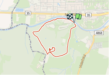
8 km | 10.9 km-effort
2h 28min
No
Trail On foot Zubří - [Ž] Zubří - Mořkov - Photo
On foot
GUIDE+

On foot

Easy
Zubří, Central Moravia, Zlínský kraj, Czech Republic
9.9 km | 14.5 km-effort
3h 17min
No


Close
My subscriptions